About Baraaweland
Welcome to Baraaweland State of Somalia
Baraaweland State was initiated in Feb.9.2010 by members of the Baraawelanders
Baraaweland State is an autonomous regional administration and
composes of 3 Regions known as Lower Shabele region, Middle Juba and
Lower Juba regions of South Somalia known as the Bread-basket of
Somalia.
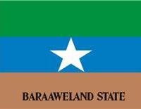
Baraaweland State have designed its
flag which contains three colors: Green, Blue, and Brown with star in the
center and on the brown color written Baraaweland State in a black color
Baraawe is not a name of tripe it is the capital city of Baraaweland State
this autonomous administration is under process
For further details of Baraaweland State you can get in touch with the Baraaweland State committees on baraawelandstate.gov@gmail.com
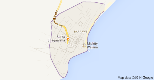
Baraawe is a place with many population in the state/region of Lower Shabeele of Somalia which is located in the continent/region of Africa.Cities, towns and places near Baraawe include: Sablaale, Eeriile, Buulo Mareer, Merka
The closest major cities include Mogadishu, Kismayo, Mombasa and Nairobi.
Distance from city: Baraawe to Top 10 cities of the world
|
Distance (Km) |
| Baraawe - Berlin | 6 356 km | | Baraawe - London | 6 913 km | | Baraawe - Los Angeles | 15 690 km | | Baraawe - Moscow | 6 029 km | | Baraawe - New York | 12 274 km | | Baraawe - Paris | 6 592 km | | Baraawe - Peking | 8 381 km | | Baraawe - Rio De Janeiro | 9 752 km | | Baraawe - Sydney | 11 653 km | | Baraawe - Tokyo | 10 391 km |
| 6 138 km
Latitude of Baraawe: | 1,1000 (16'0.000"N) |
Longitude of Baraawe: | 44,0500 (442'60.000"E) |
Altitude of Baraawe: | Preparing ! |
|
|
|
|